Barrow Haven and the Humber Estuary
Compiled by Steve Taylor.

This walk takes you from the village of Barrow to the banks of the Humber, with its expansive view of the Humber Bridge, via the Barrow Haven Inn before returning back to the village. You should allow 2 hours for this walk.
Route
The route starts out from Barrow's Market Place proceeding via High Street, the Holy Trinity Church, northwards along North Street (crossing Wold Road B1402) to Cherry Lane and takes you along a public footpath crossing over Barrow Beck (also known as the Leden). It then continues north onto West Hann Lane, via the earthwork remains of a defensive settlement known as the Castles. Turn right at the end of West Hann Lane and then walk northwards again passing The Haven Inn before proceeding to the creek at Barrow Haven and along the river bank. It then turns back along a path through the the nature Reserve, where you can enter a bird watching hide, before rejoining the return route at Barrow Haven Creek. See Map.

Start: Market Place
Start in Barrow's Market Place where you can see the relatively new statue of John Harrison (17??-17??) , depicting this famous clockmaker, examining his most accurate timepiece while standing on the globe.
More on the Village Square
More on John Harrison

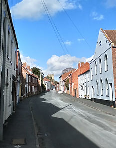
High Street
Leave the Market Place via the road to the north, the High Street, and pass by the pharmacy on the left and the butchers Sargeants on the right. Proceed along the High Street passing by the Papist Hall, one of the oldest buildings in Barrow dating to the late 1600's, and the Methodist church opposite before turning left down the snicket just before the Holy Trinity Church by the war memorial. This is the route which John Harrison would have taken many times between his workshop in Market Place where he made his H1 clock and this church where he was choirmaster.

North Street
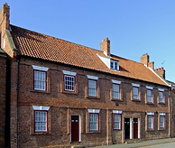
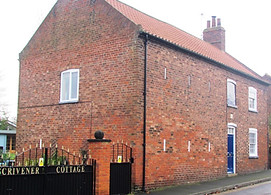
Continue along the snicket, as you pass the church tower pause to take a look at Holly House opposite, it is a Grade II listed building and it is a perfect example of a late Georgian house. Descend the path to cross over Thorngarth Lane to enter North Street. On your right you pass another Grade II listed building, Scriveners Cottage consisting of Farmhouse and adjoining barn. The datestone inscribed THOMAS. Brick with SCRIVENER 1707, (although listed as 1797 by historic England) reportedly having the smallest windows in Lincolnshire.

FP43
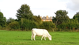
Proceed to cross Wold Road B1402 Barton Street/Ferry Road East and continue along North Street passing by numerous Georgian cottages. Turn left at the T junction with Cherry Lane takes you along a track leading between two new large houses. When you get to the field turn right along the public footpath (known as FP43), leading downhill towards Barrow Beck (also known as the Leaden). On the right you will catch a glimpse of Down Hall see photo) from which landowner Mr Beeton ran a willow farm which was used to make baskets. He is said to have monitored his workers from a glass greenhouse built onto the roof. Its size earned it the nickname 'Beeton's Folly'. The structure had forty rooms and an observatory from which William Beeton was noted to keep a careful watch on his workers. The folly had gas lighting and its own gas-making plant. When he died it is reported a riot stared because he left no money to his family, but had left his wealth to the Poor of Barrow in a Trust Fund which until recently was distributed by the church vicar. Sadly the fund was recently closed because solicitors fees had drained the funds away (check)

Barrow Beck - The Leaden
The public footpath leads via a narrow footbridge over Barrow Beck (also known as the Leaden) (see picture). This stream used to be wider; in medieval times it would have been tidal and was navigated by small boats from the Humber up as far as the village pump and watercress beds in Barrow - where the stream now passes under the B1402.
If you want to get a better view of Down Hall take a brief detour and turn right immediately after crossing the bridge where within a few hundred meters you will get a great view of Beeton's Folly, Down Hall, on the right (see picture). If you take this detour turn around, when you have seen the hall, head back and return this footbridge.
Carry on north straight on from the footbridge along the footpath uphill towards West Hann Lane and turn left when you reach the lane.


The Castles

Turning left onto West Hann Lane - walk down the lane towards Barrow Haven. Just before the first house on the left you will see the earthwork remains of a medieval fortification known as The Castles which protected the entrance of the Barrow Beck (Leaden) where it used to join the Humber. This 11th Century motte and bailey castle consisted of a mound and surrounding moat which filled at high tide from the beck (which was tidal) and which retained the water during low tide. The Castles was used in late medieval times as landfall for a Humber Ferry which crossed the estuary to the North side. The lidar image of the Castles clearly reveals the layout, with high ground appearing in brown and even higher in white.
Click Historic England for more information.

Barrow Haven
Turning right onto Ferry Road and walk northwards towards Barrow Haven. On the left you will see the Old Mill dating from xxx. On the right ocross the road is the Primitive Methodist Chapel dated 1877. Walk past or visit The Haven Inn before proceeding to the creek at Barrow Haven


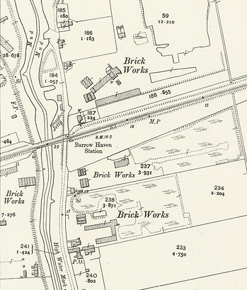
Barrow Haven Creek

Pass by The Haven Inn (you will return past it later) and proceed to the tidal creek, which is the modern entrance to the Barrow Beck from the Humber. Here you will also see the railway station. The line, now single track, was one of the earlier trains lines opened in 1846 during the first railway boom. See picture c 1926 with two steam locomotives testing the load carrying capacity of the bridge. This area was once surrounded by brickyards; the many lakes nearby resulted from hand-dug clay for the manufacture of bricks and tiles. See OS Map 1908 shown. Cross the railway bridge at Barrow Haven and turn right through a gate and along the Humber bank. The wood-yard across the creek was once the site of a public house. Wood is shipped here from with surprisingly large vessels being accommodated at the wharf.
.


Humber Bank

Pass along the river bank until you come to two gateposts with no gate, and a path to the left. Take the path to the left and see a gate on the left marked with Barrow Haven nature reserve as shown.
You may like to take a very short detour and see the picturesque view of the lakes with Humber Bridge behind (see right). If so, do not go through the gate right now, but proceed along the path away from the river bank. Shortly, within 100 meters or so, it leads to a track with a lake on each side. The stunning evening view across the lakes to the west is shown. Now turn around and return to the Nature Reserve Gate.


Nature Reserve
Pass through the gate, and follow the path. You will soon get to the bird watching hide. You can enter and raise the wooden hatches to watch the birds on the lake. Remember to lower the wooden hatches and close the door when you leave. Proceed along the path. There are deer in this area, if you are quiet you may be lucky enough to see them.
Shortly after you arrive at a metal gate where you should ascend the bank and turn right to rejoin the path by Barrow Creek.
Rejoin and return along the same route via the Barrow Haven Inn.
